
IRRIGATION INTRODUCTION Notes
About this Chapter
This study package covers the entire analytical concepts of Chapter 1: Introduction to Irrigation for the CE 354 syllabus. It provides detailed analysis regarding water application philosophies, historical milestones of irrigation development in Nepal, command area divisions (GCA, CCA), cropping dynamics, and various field methods of irrigation.
Refer to the written notes below to build strong fundamental concepts before accessing the detailed lecture notes PDF prepared for class reference.
Theory Notes: Chapter 1: Introduction to Irrigation
1.1 Definition, Need and Advantages of Irrigation and Drainage
Irrigation is defined as the artificial application of water to agricultural land according to crop requirements throughout the crop period for the full-fledged growth of crops.
- Inadequate Rainfall
- Uneven Distribution of Rainfall
- Increasing Crop Yields
- Growing Number of Crops
- Growing Perennial Crops
- Elimination of Mixed Cropping
- Optimum Benefit of Crops
- Prosperity of the Nation and Community
- Hydropower Generation and Navigation
- Facilities for Communication:
1.2 Disadvantages of Over Irrigation and Waterlogging
- Raising of the Water Table
- Waterlogging: When the water table rises up to the root zone, the soil pores become fully saturated with water. This displaces soil air, depriving crop roots of oxygen and suffocating the plant.
- Formation of Damp and Marshy Land
- Loss of Valuable Lands
- Soil Erosion
1.3 Status, Need and Challenges of Irrigation Development in Nepal
The organized development of irrigation in Nepal is categorized into four historical phases:
Phase I: Primary Phase (Prior to planned development, i.e., before the 1950s)
Traditional canal irrigation systems (known as Raj Kulo) were constructed under the royal initiatives of the Malla kings.
Early engineering-led modern developments were initiated in partnership with British engineers.
Major Irrigation facilities:
Chandra Canal: Built in 1923, it is Nepal’s first modern canal system.
Juddha Canal
Jagadishpur Irrigation System
Phase II: Infrastructure Development Phase (1950s to 1970s)
Covered the developments achieved during the First, Second, and Third Five-Year Plan periods of Nepal.
Major irrigation projects were executed under bilateral agreements and assistance from India.
Major Irrigation facilities:
Vijayapur Irrigation System
Kamala Irrigation Project
Hardinath Irrigation Project
Pashupati Irrigation Project
Phase III: Intensive Development Phase (1970s to 1980s)
Covered the Fourth, Fifth, and Sixth Five-Year Plan periods.
Development funding expanded from bilateral assistance to include multilateral donor agencies (such as the World Bank and the Asian Development Bank).
The concept of Lift Irrigation was introduced to pump water to elevated agricultural fields.
Major Irrigation facilities:
Kankai Irrigation Project
Mahakali Irrigation Project (Phase I)
Lumbini Agriculture Development Project (LADA) assisted by the World Bank
Phase IV: Integrated Development Phase (1980s to Present)
Spans the Seventh Five-Year Plan onwards.
Purely construction-focused approaches shifted toward long-term institutional sustainability and system management.
Introduced Agency Managed Irrigation Systems (AMIS) and Farmer Managed Irrigation Systems (FMIS) to enhance stakeholder participation and ownership.
High priority was given to rehabilitating and modernizing older, farmer-built canals.
Major National Projects:
Mahakali Irrigation Project (Phase II)
Babai Irrigation Project
Sikta Irrigation Project (classified as a “National Pride Project”)
- Total Land Area of Nepal: $14.718\text{ MHa}$ (Million Hectares)
- Total Agricultural Land: $2.641\text{ MHa}$
- Total Irrigable Land: $1.766\text{ MHa}$
- Existing Irrigation Facilities: $1.4\text{ MHa}$ (representing approximately 76% of the potential irrigable area, mostly situated in the Terai region).
- Surface Irrigation Facilities: $1.0\text{ MHa}$
- Underground/Groundwater Irrigation: $0.4\text{ MHa}$
- Governing/Funding Bodies: Department of Irrigation (DoI) and the Agricultural Development Bank of Nepal (ADB/N).
- Socio-Economic Need: Over $80\%$ of the population relies directly on agriculture for their livelihood, making agricultural productivity essential for the nation.
- Lack of Year-Round Irrigation: Although $1.4\text{ MHa}$ has some form of irrigation infrastructure, only about $20\%$ of the irrigated areas have reliable, well-controlled, year-round water supply. The rest remain highly dependent on seasonal river flows.
- Topographical Challenges: High elevation differences make gravity-fed systems difficult outside the Terai plains. Lifting water to the hills is energy-intensive and expensive.
- Operational Challenges: Weak management, lack of maintenance, structural damage due to floods and landslides, and lack of active farmer participation in public canals.
1.4 Crops, Their Seasons and Periods, Cropping Pattern and Intensity
Summer Crops / Kharif Crops / Monsoon Crops/ Barkhe Kheti:
Period: April 1 to September 30
Water Requirement: High water demand, relying on monsoon rains supplemented by irrigation.
Examples: Rice (Paddy), Maize.
Cold Season Crops / Rabi Crops / Winter Crops/ Hiude Kheti:
Period: October 1 to March 31
Water Requirement: Moderate water demand.
Examples: Wheat, Barley, Gram.
Eight-Month Crops:
Crops that require approximately 8 months to mature fully.
Example: Cotton.
Perennial Crops:
Crops that remain in the field and require water continuously throughout the entire year.
Example: Sugarcane.
Cropping Pattern: The spatial and temporal arrangement of crops grown on a given area of land over a year. It reflects the choice of crops, their sequence, and their proportional area.
Cropping Intensity: The ratio of the total cropped area in all seasons of a year to the net culturable command area, expressed as a percentage:
$$\text{Cropping Intensity} = \left( \frac{\text{Total Cropped Area in a Year}}{\text{Net Culturable Command Area}} \right) \times 100\%$$
1.5 Commanded Areas and Irrigation Intensity
The total land area lying between the defined outer geographic boundaries of an irrigation project. It includes Cultivated fields, plus all non-cultivated patches like residential areas, forests, roads, barren land, and local streams or ponds.
$$\text{GCA} = \text{Culturable Area} + \text{Unculturable Area}$$
The portion of the Gross Command Area (GCA) which is physically fit, fertile, and available for agricultural cultivation.It excludes Non-culturable patches like roads, buildings, forests, and saline barren lands.It represents the actual working area to which irrigation water can be physically and economically directed.
The percentage of the Culturable Command Area (CCA) proposed to be irrigated during a specific cropping season.
$$\text{Intensity of Irrigation} = \left( \frac{\text{Area Proposed for Irrigation in a Season}}{\text{Total Culturable Command Area (CCA)}} \right) \times 100\%$$
Note: If a project irrigates $50\%$ of its CCA in winter and $70\%$ in summer, the annual intensity of irrigation is $120\%$.
1.6 Methods of Field Irrigation and Their Suitability
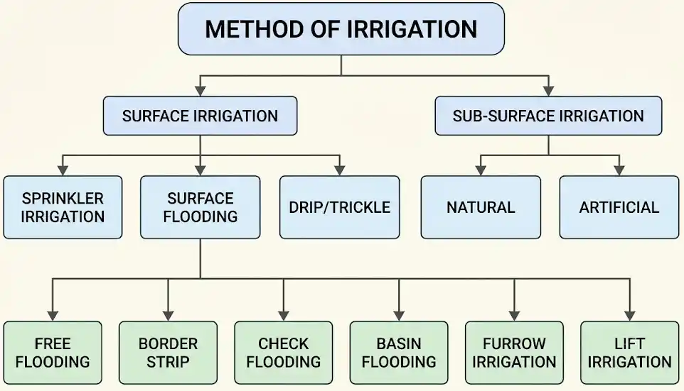
1. Surface Irrigation
In this method, water is directly applied to the surface of the field. It is mostly used in areas where water is easily available.
Types of Surface Irrigation:
- Free Flooding: The entire field is flooded with water. It is cheap to apply but has very low water efficiency. (Example: धान खेतमा पानी लगाउने ).
- Border Flooding: The land is divided into 10-15m by 60-100m strips using low borders. It is suitable for crops that grow close together.
- Check Flooding: Similar to free flooding, but the field is divided into smaller checks (from 3x2m up to 30x30m). Water is held in these checks until it percolates into the soil.
- Basin Flooding: This is specially used for orchard trees. A basin is made around each tree, and water is supplied through a ditch.
- Furrow Irrigation: Only a part of the land is wetted. Water flows through small channels (furrows), and plant roots get water through percolation. (Example: watering on potatoes field).
2. Sub-Surface Irrigation
Water is applied below the ground directly to the roots of the plants, wetting both the sub-surface and surface.
Types of Sub-Surface Irrigation:
- Natural: This happens naturally when the groundwater table is high. Plants absorb water from the ground through capillary action.
- Artificial: Perforated or porous pipes are buried underground below the root zone. Water is fed into these pipes, which helps reduce surface evaporation.
3. Sprinkler Irrigation
Water is sprayed through a pipe network like raindrops. It often uses pumps or hydraulic rams to lift the water. It has a high efficiency (90-95%) and is very useful in areas with a shortage of water. Surface ditches are not needed.
Advantages: No water lost to seepage, no need to level the land, fertilizers can be applied easily with the water, and it prevents waterlogging and salinity.
Disadvantages: High initial setup cost, requires constant energy/pressure, nozzles can get clogged, wind can blow the water away, and salty water can burn the plant leaves.
4. Drip Irrigation
This is a point irrigation method where water is applied directly to the plants drop by drop using small drippers. It can be used on the surface or underground.
It discharges water at a very low rate, making it perfect for severe water shortages. It is highly useful for fruits and vegetables.
Advantages: Helps control weeds, saves labor costs, minimizes evaporation and percolation, and doesn’t require land leveling.
Disadvantages: High maintenance, limits how far roots can grow, not suitable for closely spaced crops, and harmful salts can build up and clog the tubes.
1.7 Planning of Irrigation and Drainage Projects
Planning an irrigation project is a systematic engineering process that involves:
- Estimating Water Availability: Assessing hydrology, river discharges, catchment rainfall, or groundwater aquifer yields.
- Crop Planning: Selecting suitable crop types, identifying growing seasons, and developing the crop rotation pattern.
- Estimating Water Demand: Calculating crop water requirements, transit losses, and net water demand.
- Matching Supply and Demand: Checking if the available water source can reliably satisfy the crop water demands throughout the crop periods.
1. Primary Planning (Reconnaissance Phase)
Conducting preliminary site visits and catchment area surveys.
Locating potential sites for headworks (weirs or barrages) and intake structures.
Assessing the basic availability of water throughout the year.
2. Feasibility Study
Conducting technical, environmental, social, and economic analyses of the proposed project.
Economic Assessment Criteria:
Benefit-Cost Ratio (B/C Ratio): The ratio of annual benefits to annual costs must be greater than $1.0$ ($\text{B/C} > 1.0$).
Internal Rate of Return (IRR): Must be greater than the baseline acceptable market discount rate.
3. Final Design Phase
Preparing detailed, construction-ready engineering drawings for:
Diversion headworks (weirs/barrages, under-sluices, silt ejectors).
Main canal, branch canals, and distributaries.
Cross-drainage works (aqueducts, super-passages, siphons).
Field-level outlets and drainage channels.
- Land and Soil: Location, soil type (permeability, moisture-holding capacity), and the exact extent of the irrigable land.
- Water Source: Dependability of water supply at the source (river discharge, minimum flows during dry seasons, aquifer recharging rates).
- Cost Factor: Annual operational cost of water to the farmers (affordability index).
- Agronomy: Local cropping patterns and typical irrigation methods used by local farmers.
- Command Area: Exact boundary dimensions of the Culturable Command Area (CCA).
- Project Benefits: Expected tangible (increased crop production, hydropower) and intangible benefits (improved public health, rising living standards).
- Finance: Funding sources, loans, repayment plans, and water-rate collection systems.
Editorial Disclaimer
The educational materials provided on this website are intended as supplementary resources to support your learning journey. These study materials are sample documents designed to help students understand complex concepts.
We have made every effort to ensure the accuracy of the content. However, we recommend students to refer to standard textbooks and consult with professors for authoritative explanations. These materials should be used as references only.
We respect intellectual property rights. If you believe any content should be credited differently or removed, or if you are the author and wish for these notes to be removed, please don’t hesitate to contact us. We’re happy to make appropriate corrections or give proper attribution.